
Hallasan: Seongpanak Trail
Is the Seongpanak Trail the easiest way to summit Hallasan?
Yes — of the two trails that reach Hallasan's crater rim, Seongpanak has the gentler average grade, though it's the longer of the two at 9.6km one way. Expect 8-9 hours round trip, an online reservation, and a strict gate cutoff time.
Seongpanak is one of only two trails on Hallasan that reach the actual summit crater rim, and it’s the one most first-time hikers are steered toward — not because it’s short (it isn’t) but because its grade is the more forgiving of the two summit options. At 9.6km one way, it’s roughly 900m longer than the alternative Gwaneumsa route, and that extra distance buys a steadier, less punishing climb rather than the steeper pitches found on the other side of the mountain.
| Distance | 9.6km one way / 19.2km round trip |
| Time | 8–9 hours |
| Reaches summit? | Yes — Baengnokdam crater rim |
| Reservation | Required, since 2019 |
| Trailhead | ~30–40 min from Jeju City or Seogwipo |
The route, section by section
The trail starts in dense subtropical forest at around 750m elevation and climbs steadily through a broadleaf and conifer mix for the first several kilometers — this lower section is scenic but view-limited, which surprises hikers expecting panoramas from the start. Around the 4-5km mark you reach Sara Oreum shelter, a common early checkpoint with toilets, and the forest starts to thin. By the time you pass Jindallaebat shelter (roughly two-thirds of the way up, at about 1,500m), the terrain opens into subalpine scrub and the views genuinely begin — this is also the point rangers use to judge whether you’ll make the gate cutoff, so it functions as an informal go/no-go checkpoint.
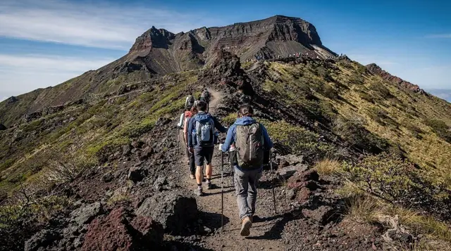
The final stretch above Jindallaebat is the most rewarding: exposed volcanic rock, dwarf pine, and on a clear day, expanding views over the island’s lower slopes. The last kilometer to Baengnokdam, the crater lake at the summit, is the steepest section of the entire route but still gentler underfoot than Gwaneumsa’s upper rock scrambles.
Reservations and the gate system
Since a 2019 reservation system was introduced, Seongpanak requires an online booking in advance, with a capped daily quota of hikers and an assigned starting window. This isn’t a formality — checkpoints along the trail do enforce cutoff times, and hikers who show up without a reservation, or who arrive at a checkpoint past the allowed window, are turned back rather than waved through. Reservation windows and daily quotas shift seasonally (shorter daylight in winter means earlier, tighter cutoffs), so check the current schedule shortly before your trip rather than relying on last season’s numbers.
Peak season weekends (spring bloom season, autumn foliage in October) fill the daily quota fastest — booking a week or more ahead is a reasonable buffer during those windows. Weekday visits, even in peak season, are noticeably easier to book.
How long it actually takes
Budget 8-9 hours round trip for most reasonably fit hikers, including a 20-30 minute break at the summit. That breaks down roughly as 4.5-5 hours up and 3.5-4 hours down — descending Seongpanak is faster than the ascent but still demanding on the knees over nearly 10km. Hikers who underestimate the descent time are the most common source of gate-related trouble, since the trail closes to new ascents well before dark but doesn’t extend descent deadlines proportionally.
If your primary goal is simply reaching a summit rather than specifically Seongpanak, Jeju: Hiking Mt. Hallasan, South Korea’s Highest Mountain and Jeju: Mt. Hallasan Small-Group Nature Hike & Lunch both handle the reservation and gate-timing logistics for you, which removes a genuine source of stress for visitors unfamiliar with the booking system.
Weather and the crater lake
Baengnokdam, the crater lake at the summit, is frequently dry or reduced to a shallow pool outside of wet periods — it’s a volcanic caldera, not a permanently full lake, so don’t build your entire hike around a guaranteed water view. Cloud cover is the bigger variable: Hallasan’s peak sits high enough to generate its own weather, and a clear coastal forecast doesn’t guarantee a clear summit. Check the mountain-specific forecast (not just the general Jeju forecast) the morning of your hike.
Winter conditions
From roughly December through March, expect snow and ice on the upper third of the trail. Crampons are effectively required for safety on this section and are available to rent near the trailhead. The park does close Seongpanak entirely after heavy snowfall or high wind, sometimes with limited advance notice, so build a buffer day into a winter itinerary if summiting matters to your trip. Jeju Island: Hallasan Mountain Winter Scenery Guided Tour is a guided winter option that supplies gear and handles permit logistics.
What to bring
Layers matter even in summer — temperatures at nearly 1,950m run noticeably cooler and windier than the coast, and the exposed upper section catches wind that the forested lower trail blocks. Proper hiking shoes are non-negotiable; the upper section has enough loose volcanic rock to make sneakers a genuine hazard. There are shelters with toilets at Sara Oreum and Jindallaebat, but no food service anywhere on the trail, so carry all your own water and food for a full 8-9 hour day. See the Jeju hiking gear and safety guide for a complete seasonal packing list.
Seongpanak vs the other three trails
Seongpanak and Gwaneumsa are the only routes to the summit; Yeongsil and Eorimok both stop at Witse Oreum, a viewpoint below the crater rim, and don’t require the same reservation system. If a full summit day doesn’t fit your schedule or fitness level, those two are legitimate shorter alternatives rather than a consolation prize — Yeongsil in particular has dramatic rock scenery in a fraction of the time. The complete Hallasan hiking guide compares all four trails side by side.
Getting to the trailhead
Seongpanak trailhead sits roughly 30-40 minutes by car from either Jeju City or Seogwipo, making it reasonably central regardless of where you’re staying. A limited public bus service reaches the trailhead, but schedules are infrequent enough that a rental car or taxi gives far more control over your start time — arriving even 15 minutes late for your reservation window can mean turning around. See the Hallasan National Park destination guide for a broader overview of the park, and the car rental guide if you’re weighing rental logistics against a taxi.
Combining Seongpanak with oreum hikes
If you’re staying multiple days near Hallasan, several accessible oreums sit within reach of the same general area and offer shorter, no-reservation hikes for a rest day between summit attempts. The best oreums guide and Geumun-oreum crater hike both cover options that don’t require the summit trail’s booking system or full-day time commitment.
Cost of a Seongpanak hike
The trail itself carries no fee, and the current reservation booking has no separate charge beyond the online registration. Real costs come from getting to the trailhead — a taxi from Jeju City runs roughly ₩25,000-35,000 (about $18-25) one way, while a rental car spreads that cost across a full day of other driving. Winter crampon rental near the trailhead typically runs ₩5,000-10,000 (about $4-7) for the day. If you book a guided hiking tour instead of going independently, expect to pay considerably more than the sum of transport and gear costs, but you’re buying out the entire reservation and logistics headache along with a certified guide and lunch — a fair trade for many visitors short on planning time.
Notable viewpoints along the way
Beyond the summit itself, Seongpanak has several worthwhile stops that reward attention rather than a heads-down march to the top. The transition zone around Jindallaebat shelter, where dense forest gives way to subalpine scrub, offers the trail’s first real long-distance views back toward the coast — a good spot for a longer break given the shelter’s toilets and relatively flat ground. Azaleas (jindallae, which gives the shelter its name) bloom here in late spring, adding color to what’s otherwise a fairly uniform green backdrop for much of the ascent. Near the summit, the exposed rock sections offer increasingly wide views with each switchback, and clear autumn mornings in particular can deliver visibility extending toward Jeju’s coastline on multiple sides.
Common mistakes on this trail
The most frequent error is underestimating descent time — hikers who reach the summit with plenty of daylight left sometimes linger too long, not accounting for how much slower and more knee-taxing the nearly 10km descent becomes after an already tiring ascent. A second common mistake is starting without enough water, assuming the shelters along the way sell drinks (they generally don’t; they offer toilets and rest space, not food service). A third: checking only the coastal Jeju weather forecast rather than a mountain-specific one, then being caught off guard by cloud or wind at elevation that the coastal forecast gave no hint of.
Fitting Seongpanak into a broader Jeju itinerary
Because a full Seongpanak hike consumes the better part of a day, most itineraries treat it as the single dedicated activity for that day rather than pairing it with much else — by the time you’re back at the trailhead in the afternoon or early evening, most visitors are ready for food and rest rather than another attraction. If you’re building a multi-day Jeju trip around hiking, a reasonable pattern is a Hallasan summit day followed by a lighter recovery day exploring Jeju City or Seogwipo at an easy pace, rather than stacking Seongpanak against another demanding hike immediately after.
Seasonal conditions month by month
Spring (late March through May) brings mild trailhead temperatures but colder, windier conditions persisting at the summit later into the season than the coastal weather would suggest — azaleas bloom near Jindallaebat in late spring, adding real color to the middle section. Early summer (June) is comfortable but increasingly humid, and by July the monsoon rains bring a genuine risk of trail closure or a thoroughly unpleasant, low-visibility hike if you push ahead regardless.
August carries typhoon risk that can force last-minute cancellations of any Hallasan plan, guided or independent, and the heat and humidity at lower elevations make even a successful hike considerably more taxing. September through October is widely considered the best window — cooling temperatures, drier air, and by October, the autumn foliage that draws Hallasan’s biggest hiking crowds of the year, meaning reservation quotas fill fastest in this window. November transitions toward winter conditions at elevation while the coast stays comparatively mild. December through March brings the snow and ice covered earlier, with the shortest daylight windows and tightest gate cutoff times.
What first-time visitors get wrong about the difficulty
A recurring pattern among first-time Hallasan hikers is assuming that because Jeju is a beach-and-leisure destination overall, its signature hike will be similarly easy-going. Seongpanak is not a leisurely nature walk — it’s a genuine full-day mountain hike covering nearly 20km round trip with over 1,300m of elevation gain, comparable in scale to many well-known day hikes elsewhere in the world that hikers would never describe as casual. Visitors who arrive underprepared, physically or logistically, tend to either turn back partway or finish in genuine discomfort. Conversely, visitors who treat it with appropriate seriousness — proper gear, adequate water and food, a realistic pace, and respect for the gate cutoff — generally have a very manageable, rewarding day. The mismatch between expectation and reality, more than the trail’s actual difficulty, is what catches people out.
Accessibility considerations
Seongpanak’s official reservation and gate system, along with its rest shelters at roughly the one-third and two-thirds marks, make it somewhat more structured and predictable than a completely unmarked backcountry route, which helps hikers with moderate mobility limitations plan realistically around rest points. That said, the trail is not wheelchair accessible and involves sustained walking over natural and occasionally uneven terrain for the better part of a day — it is not a hike that accommodates significant mobility restrictions. Families hiking with children should realistically assess whether a child can sustain roughly 8-9 hours of walking; younger children are generally better suited to one of the shorter, non-summit trails or an oreum climb instead.
Reading the trail’s traffic patterns
Seongpanak, as the more commonly recommended of the two summit trails, tends to draw the heaviest foot traffic on Hallasan, particularly on weekend mornings during peak reservation windows. Starting at the earliest available slot within your assigned window, rather than the latest, generally means sharing the trail with fewer other hikers in the crucial lower and middle sections, and reaching the summit before the busiest midday crowd arrives. Weekday hikes, even during peak season, are noticeably quieter across the full length of the trail — worth prioritizing if your schedule allows flexibility on which day of the week to attempt the summit.
The descent deserves its own planning
Much of the practical advice around Seongpanak focuses on the ascent, but the descent carries its own distinct challenges worth planning for separately. Nearly 10km of continuous downhill walking places sustained strain on knees and ankles that differs meaningfully from the cardiovascular demand of climbing, and hikers who paced themselves well on the way up sometimes underestimate how much the descent will test different muscle groups. Trekking poles genuinely help distribute this strain, and a slower, more deliberate pace on the steeper sections near the summit reduces the risk of a slip on loose rock when legs are already tired from the ascent.
A final planning checklist
Before setting out on Seongpanak, confirm your reservation is active for the correct date and starting window, check the mountain-specific forecast rather than the general coastal one, pack layers plus 1.5-2 liters of water and real food, wear broken-in hiking shoes rather than new ones, and plan transport to and from the trailhead with enough buffer to arrive before your assigned start time. None of this is complicated, but skipping any single item is the most common source of an unnecessarily difficult day on this trail.
Seongpanak within the wider Hallasan picture
Seongpanak is one of four established Hallasan routes. The complete Hallasan hiking guide compares it directly against Gwaneumsa, Yeongsil, and Eorimok by distance, difficulty, and reservation rules, useful if a full summit day isn’t yet a firm decision.
Frequently asked questions about the Seongpanak Trail
How long is the Seongpanak Trail?
9.6km one way to the summit (Baengnokdam crater rim), so 19.2km round trip. Most hikers take 8-9 hours total including a summit break.
Do I need a reservation for Seongpanak?
Yes. Since 2019, both summit trails require an advance online reservation through the Hallasan National Park system, with a daily hiker quota and an assigned starting-time window.
What time do I need to start?
Gate cutoff times vary seasonally but generally require starting by mid-morning at the latest — often as early as 5:30-6:30am in shorter-daylight months. Check current times before booking, since rangers do enforce them at the checkpoint.
Is Seongpanak harder or easier than Gwaneumsa?
Easier in terms of grade — Seongpanak climbs more gradually over a longer distance, while Gwaneumsa is shorter but steeper with rockier upper sections. Total effort ends up fairly similar.
Can I do Seongpanak in winter?
Yes, but expect snow and ice from roughly December through March, and crampons are effectively mandatory for the upper section. Trail closures after storms happen with little notice.
Is there a rest stop or shelter on the trail?
Yes — Jindallaebat shelter sits roughly at the two-thirds point and is a common turnaround marker for the gate cutoff; there are toilets and a place to refill water, but no food service.
How do I get to the Seongpanak trailhead?
It’s about 30-40 minutes by car from Jeju City or Seogwipo. A limited public bus service also reaches the trailhead, but schedules are infrequent — check current timetables if you’re not driving.
Related guides
Hiking Hallasan: Complete Guide
Compare all four Hallasan trails — Seongpanak, Gwaneumsa, Yeongsil, Eorimok — by distance, difficulty, reservation rules, and what each one delivers.

Hallasan: Eorimok Trail
Eorimok is the gentlest of Hallasan's four trails, climbing toward Witse Oreum from the west — no reservation, roughly 4.7km one way.

Hallasan: Gwaneumsa Trail
Gwaneumsa is the shorter but steeper of Hallasan's two summit trails — 8.7km one way, rockier upper sections, reservation required.

Hallasan: Yeongsil Trail
Yeongsil climbs to Witse Oreum below Hallasan's crater rim — no summit reservation needed, dramatic rock formations, roughly 3.7km one way.
Ready to book? Top tours for this guide
We earn a small commission if you book through GetYourGuide — at no extra cost to you. Every tour is hand-picked and verified.
Jeju: Hiking Mt. Hallasan, South Korea's Highest Mountain
Jeju Island: Hallasan Mountain Winter Scenery Guided Tour
Jeju: Mt. Hallasan Small-Group Nature Hike & Lunch
Jeju: UNESCO Sites & Sunrise Peak Hiking Small Group Tour
Jeju South: Small Group Healing Tour w/Mt.Halla & Olle Trail
